 |
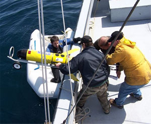
| Adam Comeau (in small boat), a Dalhousie master's student in oceanography, helps bring in the Slocum Glider. Jim Smith, Gus Cameron and Scott McLean assist from the larger vessel. |
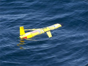
It floats like a bird. It looks like a plane. But don’t look up in the sky if you’re expecting to find these gliders—recast your gaze to the deep blue sea, where a Beatles-like “yellow submarine” can be found soaring beneath the waves.
The Slocum Glider takes its nickname from Joshua Slocum, a Nova Scotian who was the first person to sail single-handedly around the world. And like its namesake, the unmanned glider is amazingly independent. It can dive for days or even weeks before being recovered. It conserves energy by using ocean currents while it “glides” up and down through the water. It can dive from 10 metres up to as deep as 2,000 metres before resurfacing and sending the data it collected to researchers via satellite. And, best of all, it’s considerably cheaper and more energy-efficient than commissioning ships to canvas the ocean for days on end.
No wonder Marlon Lewis calls gliders “the future of oceanography.”
“You see much more detail than you would ever see in a ship,” explains Dr. Lewis, professor of oceanography at pilipiliÂţ» and founder of Satlantic Incorporated. “They can take measurements with higher resolution and can travel in far worse conditions. They’re pretty amazing.”
 |
| The Slocum Glider is an autonomous vehicle which moves up and down in the ocean by changing buoyancy. |
Since early March, Dr. Lewis and his fellow Dalhousie oceanographers John Cullen and Katja Fennel have been checking their computers for daily updates from the RU15 Slocum Glider making its way through the Atlantic Ocean from New Jersey to Nova Scotia. Launched by a team of colleagues at Rutgers University – world leaders in working with these devices – the RU15 was embarking on its longest journey to date, pushing the boundaries of how far this technology can go.
To ensure that the glider had enough juice to survive the trip, a creative energy-saving route was used. After crossing the continental shelf, the glider “flew” into the Gulf Stream and used the current’s natural movement to guide its path before exiting and following the Halifax Line—a traditional oceanographic transect—to shore. During its two-month journey, it survived a storm with 25-foot seas, got caught in a warm core ring, and had a close call with a Gulf Stream meander.
The entire time, the glider was sending back valuable data about ocean temperature, salinity and density. For Dr. Fennel, this data can provide key information for her oceanographic modeling. As an example, she describes how the gliders can be used to explore changes to the coastal current system transporting cold and fresh water from the Labrador Sea along the east coast.
“It’s something that we expect to change dramatically with global warming and the melting of the ice caps,” she explains. “With glider capability we have the chance to observe and understand these changes. They open our observational window, and enable us to do things that we haven’t done before.”
Dr. Cullen agrees: “They have a spectacular capability to cruise through the oceans and tell us a number of things about the ocean interior. This is really connecting the dots for what we do as oceanographers.”
Last week, the glider was recovered 30 nautical miles offshore of Halifax by a team from Dalhousie and Satlantic, after completing a voyage of 2,600 km, measuring more than 2,150 vertical oceanographic profiles. The team from Rutgers hopes to lead further voyages in the future, and plans are for three similar gliders to be purchased and utilized as part of the Dalhousie-led Ocean Tracking Network.
